This post will make more sense in the coming future, but today, let's answer a question no one wants the answer to (whilst discussing less relevant information along the way):
Where is South London?
Obviously, South London is that half of London south of the Thames, including the boroughs of:
- Bexley, Bromley, Croydon, Greenwich, Kingston, Lambeth, Lewisham, Merton, Richmond, Southwark, Sutton, and Wandsworth.
This is a great start - except:
- Not all of Richmond is south of the River Thames - it's about an even split, in fact - areas such as Ham and Petersham are south of the Thames, yet areas like Twickenham are north of the Thames.
- However, it's not really a north-south divide here - instead, it's more like an east-west split.
- The Boundary Commission did not include the area of Richmond west of the Thames in its South Thames region in a 2018 study (page 60).
- Furthermore, can you even really consider Richmond South London? It's very different culturally to places such as Lambeth and Croydon, what with a large portion of it being a park which has deer.Let's forget Richmond, then, for a second - Hounslow could easily also constitute South London if we took the concept of a south London literally - the southern half of London - except, obviously, it's north (more west) of the Thames, so Wikipedia, for example, doesn't care.
That's a start, at least, though - surely everyone can agree that places such as Croydon, for example, are in South London.
Or can we? (The answer is yes, but there is some history behind this, and it's interesting.)
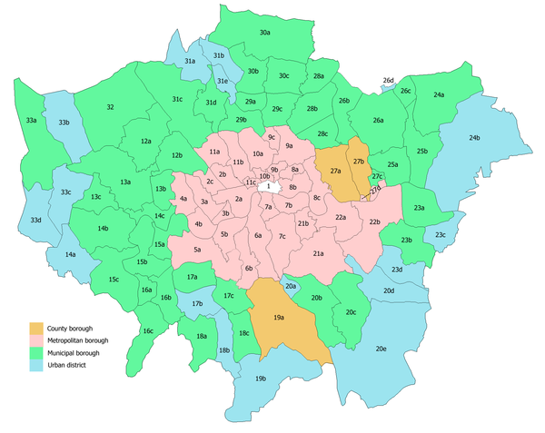
London used to look very different - the southernmost point in London would have been near Camberwell, for example. Look at this map (source - Wikipedia):

The boroughs in the middle in pink (excluding the City of London which doesn't matter here) all made up the County of London before 1965, when it was decided London should expand to the whole area on the map. Large swathes of Kent and Surrey were broken up, and Croydon and Bromley are now both in London. Yes, it's been over fifty years, but in terms of time, that isn't all that much, and to this day, postcodes still reflect how certain areas haven't always been in London (like DA - for Dartford - in Bexley).
What about broadcasting areas? BBC London covers parts of Surrey and Kent, for example, whereas ITV London also covers parts of areas outside of London too. Obviously, though, these are technicalities, not legal boundaries, so the argument that Crawley could be in London for example is very weak. For much the same reason, Gatwick Airport, though officially London Gatwick and in the Oyster fare zone, couldn't possibly be considered south London.
In other words, many places are lumped together with London out of convenience, so we can only truly focus on the legal boundary of London, which, yet again, hasn't always been set in stone.
Even then, you have areas that are south of the river that don't particularly feel like South London. Waterloo and London Bridge, for example, are very different to Croydon and perhaps are more alike to Central London. But then again, that shouldn't matter - areas can differ by a lot depending on where you are, and since London is one of the biggest cities in the world, that area is going to be very large. And obviously, the areas could be a mix of the two regions as well.
There are also the anomalies of Blackfriars Bridge and London Bridge, which are maintained in full by the Bridge House Estates. They have existed since 1282 (so much more defined than Greater London) and is overseen by the City of London (which is even older so even more defined than Greater London). So the bridges aren't actually part of Southwark, which, based on the definition at the start based on the London boroughs makes them more Central London than South London (though the London Plan wouldn't necessarily disagree with that).
At the end of the day, it's London - even if large swathes of it weren't always in London.

interesting examination of the topic
ReplyDelete